准格尔旗2022年生态变化及黄河凌汛分析

打开文本图片集
基金项目 准格尔旗科技创新项目“准格尔旗黄河凌汛风险预测研究”(2020YY-03)。
作者简介 马越界(1985—),男,内蒙古鄂尔多斯人,高级工程师,主要从事天气预报、强对流天气分析研究。
收稿日期 2023-09-10
Ecological change and Yellow River ice flood analysis in Zhungeer Banner in 2022
Ma Yue-jie (Inner Mongolia Autonomous Region Zhungeer Banner Meteorological Burea, Ordos, Inner Mongolia 010700)
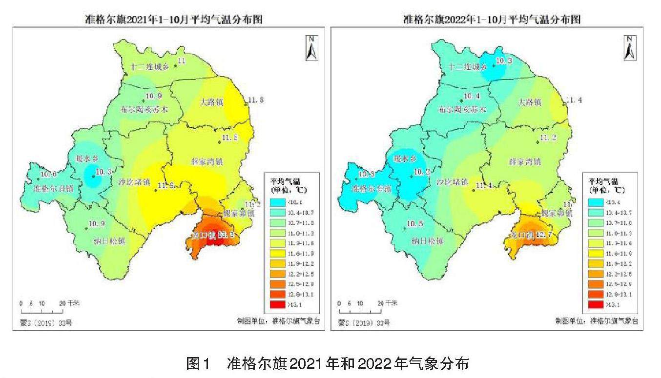
Abstract An analysis was conducted on the climate conditions, ecological changes, remote sensing of key industrial and mining areas, and the progress of river opening in the Ordos section of the Yellow River in Zhungeer Banner in 2022 and 2021. The following conclusions were drawn: (1) The temperature in Zhungeer Banner was slightly higher from January to October 2022, and the groundwater level was affected by less precipitation in the early stage, resulting in a lower water level. Since the beginning of the flood season, the water level has significantly increased and the groundwater level has decreased; (2) From early August to early September 2022, the vegetation coverage of Zhungeer Banner reached its peak throughout the year. Due to the influence of precipitation, the overall vegetation coverage of the entire banner was better than that of previous years and the same period last year after the end of the flood season; (3) The water area of Shuijing Lake in Zhungeer Banner is 25 7000 square meters, a decrease of 9 000 square meters compared to the same period in 2021; The Kubuqi Desert area in Zhungeer Banner is 53.07 km2, accounting for approximately 0.69% of the entire Banner, which is 8.46 km2 larger than the desert area of the same period in 2021; (4) In terms of remote sensing monitoring of the Yellow River ice flood, a total of 25 clear ditches were discovered in the Zhungeer Banner section of the Yellow River during the river opening period, with a total area of approximately 6.65 km2. The scope of clear ditches is gradually expanding.
Key words Remote sensing; Ecological change; Ice flood
摘要 分析了准格尔旗2022年和2021年年度气候条件、生态变化、重点工矿区遥感和黄河鄂尔多斯段开河进度,得出以下结论:(1)准格尔旗2022年1—10月气温略高,地下水位前期受到降水量偏少影响,水位偏低,汛期开始至今,水位明显上涨,地下水位数值缩小;(2)2022年8月初至9月初准格尔旗植被覆盖度达到全年峰值,受降水影响,全旗植被覆盖度在汛期结束后,总体优于历年及去年同期;(3)准格尔旗境内水镜湖水体面积为25.7万m2,较2021年同期缩小0.9万m2;准格尔旗境内库布齐沙漠面积为53.07 km2,约占全旗0.69%,较2021年同期沙漠面积相比偏大8.46 km2;(4)黄河凌汛遥感监测方面,开河期间黄河准格尔旗段共发现清沟25条,总面积约为6.65 km2,清沟范围在逐步扩大。(剩余2784字)
