1970—2020年我国雪灾的时空分布特征及其风险评估区划分析

打开文本图片集
作者简介 朱万林(1995—),安徽六安人,主要从事气象灾害过程监测研究。*通信作者:武于洁(1988—),山西吕梁人,副研究员,主要从事天气气候数值模拟预测、遥感监测应用等,E-mail:wuyujie@piesat.cn。
收稿日期 2023-08-11
Spatiotemporal Distribution Characteristics and Risk Assessment Zoning Analysis of Snow Disasters in China from 1970 to 2020
Zhu Wan-lin et al(Nanjing Aerospace Hongtu Information Technology Co., Ltd, NanJing, Jiangsu 210012)
Abstract Analyzed the spatiotemporal distribution characteristics and risk assessment zoning of snow disaster factors in China from 1970 to 2020 based on ERA5 hourly reanalysis data and population economic spatial distribution data. The results show that: (1) In the past 50 years, the factors causing snow disasters in China have shown a significant downward trend; In terms of spatial distribution, it is larger in the Qinghai-Xizang Plateau, northeast and northern Dzungaria, smaller in Central China, and smallest in southern coastal areas of South China, northern China and southern Southern Xinjiang; (2) The areas with high and high snow hazard risk level are mainly located in the Qinghai-Xizang Plateau and northern Dzungaria. The snow hazard risk level in Northeast China is low, and other areas are basically low; (3) The population and economic risks are high risks and high risk levels are mainly located in the eastern part of the Qinghai-Xizang Plateau, the North China Plain and the eastern coastal areas. This article explores the hazards and risks of snow disasters, which can serve as a reference for understanding and understanding China’s snow disasters and their impact on population and economy.
Key words Snow disaster; Disaster causing factors; Number of blizzard days; Maximum snow depth; Accumulated snowfall; Risk assessment zoning
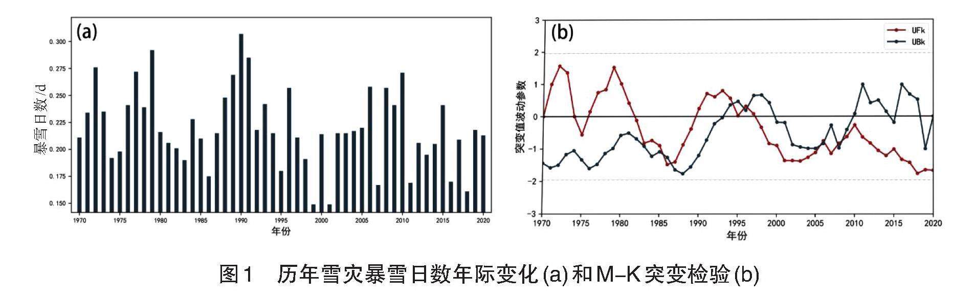
摘要 基于ERA5逐小时再分析资料和人口经济空间分布等数据,对1970—2020年我国雪灾致灾因子的时空特征和风险评估区划结果进行分析。(剩余4104字)
