无验潮与有验潮水下地形测量精度分析研究
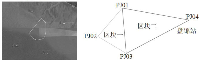
打开文本图片集
中图分类号:TP39 文献标识码:A 文章编号:2096-4706(2025)16-0142-04
Precision Analysis Research on Underwater Topographic Surveying without Tidal Observation and Tidal Observation
WANG Bing, FENG Yingxu (China Water Resources Beifang Investigation,Design and Research Co.,Ltd.,Tianjin 3oo222,China)
Abstract:Underwater topographicsurveying technology is primarilydivided intotwomodes of the tide-free and tidedependent.To systematically evaluate the measurement accuracyof these two modes,this project selects a tidal zone in PanjinCity,LiaoningProvinceasthexperimentalsite.Underthesameexperimentalconditions,RTKtide-freeunderwater topographic surveying and tide-dependent underwater topographic surveying areconducted.At the same time,the more accurate airborneLiDARpointclouddataisusedasthe true value forcomparative analysis,andtheresultsshow that in terms ofaccuracy,thedepthmeasurementaccuracyoftide-dependentandtide-freemethodsisquitesimilar,butthetide-freedepth measurementisslightlymore accurate.Aprerequisitefortide-free depth measurementis that the surveying mustbeconducted inareascovered byarefined geoid model. Otherwise,traditional tide-dependent depth measurement methods mustbe used for topographic surveying.
Keywords:underwater topographic surveying;without tidal observation;tidalobservation;airbome laserrada
0 引言
水下地形测量是指测量江河、湖泊、水库、港湾和近海水底点的平面位置和高程进行测量,用以绘制水下地形图的测绘工作。(剩余5308字)
