智慧蔗田“空-天-地"协同智能监控系统设计与应用

打开文本图片集
中图分类号:S126 文献标志码:A 文章编号:2096-9902(2025)24-0006-05
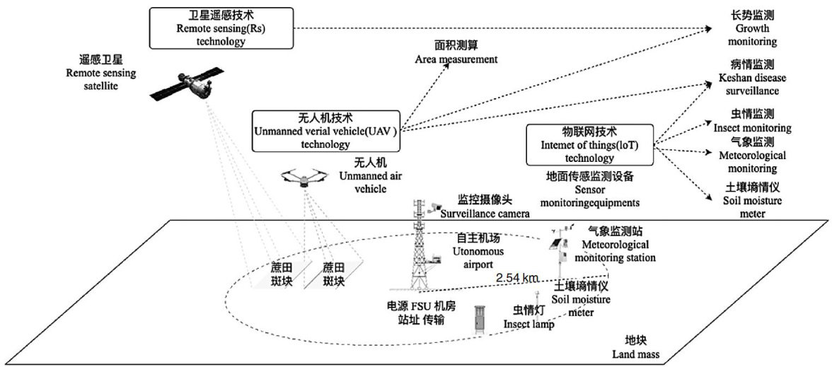
Abstract:Inviewoftheproblemsofinsuffcientmonitoringaccuracy,incompletedatacoverageandlowintelligencelevelin theconstructionofadigitalmanagementsystemforGuangxi'ssugarcaneindustrythisstudyproposedandimplementedaetof "air-sky-ground"integratedcollborativeintellgentmonitoringsystembasedondroneremotesensingtechnologyanddeep learningmethods.Thesystemreliesontheexisting infrastructureofthetowerbase,combinesdroneautonomousairportaerial photographytechnologywithartificialinteligenceimagesegmentationalgorithm,mediumandhighpointvideosurveillnce technology,Iteetofingssensingmitoringtecogtc.touilda"pereptiotransisio-platfoaplicati"four layerarchitecturesystem,andintegratescollaborativedronetaskmanagement,orthophotoanalysis,imagesegmentationand quantitativeevaluationmethodsbasedontheimprovedU-Netmodelandmulti-terminalcolaborativedecision-makingtobuild anintegratedcoremonitoringfunctionmodule.TheoverallsystemadoptsB/Sarchitecture,isdesignedseparatelyfromthefront andbackends,andusesadistributeddatabasetoachieveeficientstorageandaccessoflarge-scalecoleteddata.Theactual measurement results show thatthe coverage radius of single drone tower base monitoring and acquisition can reach 2.5km (about 1963.5hectares),coveringatotalareaofabout3OOoOacres,andtheerorofautomaticareacalculationofsugarcanefieldsis controlled within 5% . Theresearchresultsshow that thesystem has outstanding performance in field identification accuracy,data visualizationandagriculturalmanagementeficiencyThiscanprovidedatasupportforprecisemanagementoftheentireproce, allfactorsandallweatherconditionsofsugarcanefieldproduction,andpromotethedigitaliationofGuangxi'ssugarcane industry,with important application value and promotion prospect for intelligent construction.
Keywords:remotesensing technology;deeplearning;crop identification;areameasurement;yieldestimation;image segmentation
广西作为我国糖料蔗产业主要地区,当前糖料蔗“双高"(高产、高糖)基地面积已超1100万亩(1亩约等于 667m2 ,下同)。(剩余4906字)
