城镇地质灾害风险调查评价斜坡单元划分方法研究

打开文本图片集
中图分类号:P642 文献标志码:A 文章编号:2095-2945(2025)19-0144-05
Abstract:Throughtheivestigationofslopeunitdivisionmethodsandaplication,wecolecteddataonthequalityandeicincyof slopeunitdivisionfrom15projectgroups,andanalyedthatthemainreasonsforthepoorqualityandloweficiencyofslopeunitdivision are DEM data accuracy,division method,and threshold setting.Aiming at the above reasons: ① 5,8,and 12.5 m precision DEM data are used respectively; ② Global Mapper software optimizes the slope unit division method; ③ Compare the countermeasures for dividing the 1000,2000,Oo4,O00,ndotresldvluesinhsmearea.nalltatisticalalysisasedoutby comparingtheareadistributionof slopeunits,perimetersquareandarearatio.Atthesametime,therationalityandtimeconsumptionof 15projectgroups todivideslopeunitswerecounted.Theresultsshowthattheimprovementofslopenitdivisionmethodissimpleand easytooperate,andhasgoodqualityandeconomicbenefits.Itcanmettherequirementsofurbangeologicaldisasterisksurveyand evaluationprojectsfurterimproveteaccuracyofevaluatiosultsndbeerprovidesupportforgologicaldisasterskautio.
Keywords:slope unit; geological disaster;ArcGIS;Global Mapper;risk investigation and evaluation
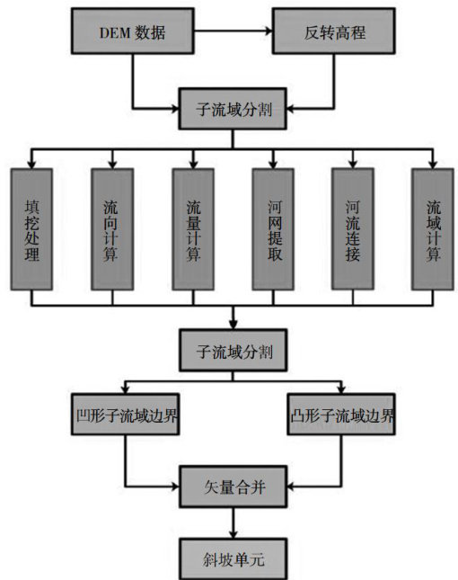
城镇地质灾害风险调查评价通常为选取某种评价单元,对某一特定区域,在某种特定条件下发生地质灾害时造成的人员、经济等损失的可能性预测。(剩余3743字)