基于FY-4卫星遥感的一次西南涡暴雨过程分析

打开文本图片集
Analysis of SouthwestVortex Rainstorm ProcessBased on FY-4 Satellite Remote Sensing
WANG Xueqin GAO Hengzhou HU Chao (Meishan Meteorological Bureau,Meishan 62OO1O, China)
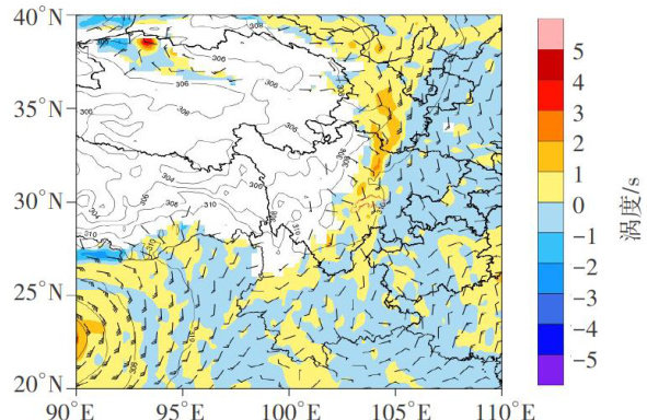
Abstract:[Purposes] This study aims to analyze the weather characteristics of southwest vortex rainstorms using FY-4 meteorological satellite remote sensing data,so as to provide references for improving the accuracy of short-term nowcasting of heavy rainfall.[Methods] Taking the southwest vortex rainstorm process in Meishan,Sichuan Province from September 14 to 15,2024 as an example,FY-4 satellite infrared and water vapor cloud images,along with Fengyun Earth satellite products, were used to diagnose and analyze strong convective cloud clusters.[Findings] ① Cloud clusters induced by highaltitude weather systems (low vortex and shear) tend to merge and develop. The detection of growing cloud clusters near high-altitude weather systems via infrared cloud imagery suggests that convection is likelyto develop,warranting heightened attention; ② Water vapor cloud imagery clearly revealsatmosphericregions of ascending and descending motion.Within rainstorm cloud clusters,there is intense large-scale vertical ascent,accompanied by sufficient moisture throughout the atmospheric column, providing favorable hydrological and dynamic conditions for heavy rainfall; ③ Fengyun Earth satellite products are efective in assessing the atmospheric environmental field and interpreting the physical properties of strong convective cloud clusters.[Conclusions] The use ofFY-4 meteorological satelite remote
sensing data can help predict the development of convection, which is of great significance for improving the accuracy of short-term nowcasting of rainstorms.
Keywords:FY-4;satellite cloud imagery;southwest vortex
0 引言
西南涡是我国青藏高原东部特殊地形与大气环流共同作用的结果。(剩余3970字)
