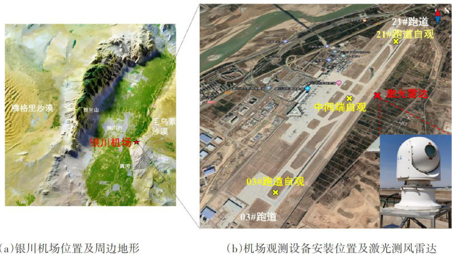
银川机场一次对流云引发低空风切变的激光雷达特征分析

打开文本图片集
Lidar Characteristics AnalysisofLow-Level Wind Shear Caused by a Convective Cloud at Yinchuan Airport
LI Tao PAN Jia WANG Xiaolang (Meteorological Observatory of Ningxia Branch of Northwest Air Traffic Management Bureau of Civil Aviation of China, Yinchuan 750004, China)
Abstract: [Purposes] This study aims to analyze the wind field evolution characteristics of low-level wind shear caused by convective clouds,so as to provide reference for the forecasting and early warning of such events.[Methods] Using FC-Il laser wind radar data,the wind field evolution characteristics of two successve low-level wind shear events triggered during the development and movement of a typical convective cloud at Yinchuan Airport were analyzed.[Findings]The results show that the thunderstorm weather was triggered bythe combination of a low-level shear lineand high-altitudecold advection.As the convective system developed and moved,the gust front affcted Yinchuan Airport twice from the northwest and northeast directions,respectively.From the laser wind radar's DBS and RHI mode images, two invasions of near-surface cold advection and their forced lifting leading to intensified updrafts were observed,along with awedge-shaped negative velocity zone formed by the gust front advancing toward therunway in the lowerlayer.Inthe LiDAR PPI mode,itcan be seen that the diffsion and advancement of the two gust fronts caused moderate wind shear at the wind convergence zone. Compared with surface observation equipment,the laser radar detected the two low-level wind shear events with lead times of 6 minutes and 2O minutes,respectively.[Conclusions] The findings can provide a basis for early warning of low-level wind shear incivil aviation.
Keywords: gust front; low-level wind shear; laser wind radar;aviation meteorology
0 引言
发展强盛的对流云产生的强下沉气流在地面辐散的外流边界被称为“阵风锋”。(剩余6337字)
