海洋平台场址工程勘察数据库设计研究

打开文本图片集
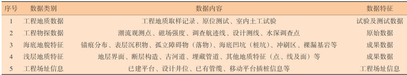
Abstract:Withtheadvancementof thecarbon peakingandcarbonneutralitygoals,China'sofshoreoilandgasexplorationand offshorewindpowerdevelopmenthavesignificantlyexpanded,resultinginanexponentialgrowthinmarineengneeingsueydata. However,theutilizationrateofexistingsurveydataremainslow.ThispaperproosesaGIS-baseddesignschemeforanengineering surveydatabaseofofshoreplatforsitestoadresstheulti-sourceheterogeneouscharacteristicsofmarineengineeringsurveydata. Thedatabaseintegratesfivemajorfeaturedatasets (41featureclases),theetypesofrasterdataandnonfeaturedatasuchasrious businessentitytables.Populatedwithdatafromover5OsitesintheBohaiSea,itenablesmulti-datacorrelationandintegrated visualization.Enginingvalidatndmosratestatthatabseftielysupprtsalytalevaatiosfotialtmparypile positioning ofmobileplatforms,platformpileinstallation,andsitegeohazardassssments,improvingdatareuseatesfrom 18% to 67% : This research provides a standardized and scalable infrastructure for intelligent marine engineering.
Keywords:marine engineering survey; database; GIS
国家《“十四五”规划和2035年远景目标纲要》明确提出了“加快数字化发展、建设数字中国”的战略部署。(剩余6846字)
