无人机高光谱影像在农业长势监测中的应用

打开文本图片集
中图分类号:S25 文献标志码:A 文章编号:2096-9902(2025)14-0037-04
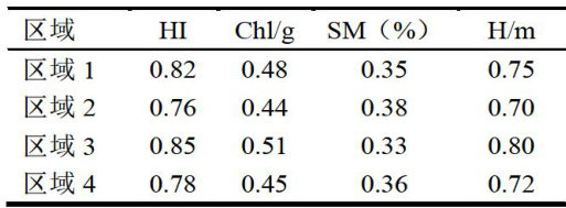
Abstract:ThisstudyisbasedonUAVhyperspectralimagingtechnologyandexploresitsapplicationinagriculturalgrowth monitoring.Amodelofcropgrowthwasconstructedandhyperspectralimagedatawasusedtoconductin-depthanalysisofchanges inkeyidicatossuchsopalthindex(H,hrophylloncentration(Ch)soilmoisture(S)ndoheight(Hilation resultsshowedthatthecrophealthindex(H)increasedfromOOtoO.86,thechlorophyllcontent(Cl) increasedfromO.45to0.52 andsoilmoisture(SM)andcropheight(H)alsoshowedstableincreasingtrendsrespectively.Thesechangesreflectthecontiuous improvementofcropgrowthconditions,indicatingthattheoptimizationofenvironmentalconditionsplaysanimportantrolein promotingcropgrowthinagriculturalproduction.Thenumericalsimulationandon-sitemonitoringdatawerecomparedtofurther prove the efectiveness and accuracy of UAV hyperspectral imaging technology in monitoring agricultural growth.
Keywords: UAV; UAV image; hyperspectral image; agricultural growth monitoring;precision agriculture
随着现代农业对精确监控与管理要求的日益提高,传统农业监测手段已经不能适应高效、实时的要求了。(剩余5261字)