一种基于多层水平集的无人机红外图像野火边界提取方法

打开文本图片集
中图分类号:TP391.41;TN219 文献标识码:A 文章编号:2095-2953(2025)06-0067-06
A Multi-Level Set-Based Method for Wildfire Boundary Extraction from Unmanned Aerial Vehicle Infrared Imagery
FU Yi-fan’, SHI Tie-feng² * , ZHANG Zhong-liang 2 , LI Xing-dong1 (1. 15O40,China; 2. o,China)
Abstract:The proliferation unmanned aerial vehicle (UAV)technology has significantly exped itsapplication in wildfire detection.Accurateeffcientsegmentation infrared wildfire imagescaptured by UAVs is crucial for timely firefighting.This paper proposesanovel multi-level set-based image segmentation method toaddressthe limitations traditional methods in hling wildfire images,such as low segmentationaccuracy sensitivity to noise. Byleveraging theadvantages levelset models in hlingcomplex topologies,theproposed method effctivelyavoids the interference wildfire shadows surounding environmental highlights,enabling effcientsegmentation dispersed irregularlyshaped wildfire regions.Experimental resultsdemonstrate thattheproposed method outperforms traditional unsupervised segmentation methods in terms robustnessaccuracy when applied to wildfire images,providing a reliable basis for subsequent wildfire boundary measurement localization.
Key words: wildfire;unsupervised segmentation;multi-level set; UAV monitoring
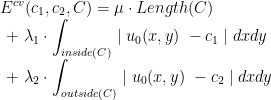
近年来,无人机技术的迅猛发展为野火监测提供了全新的方法。(剩余8793字)
