基于多源数据的地上地下一体化模型构建研究
——以北京西南三环区域为例

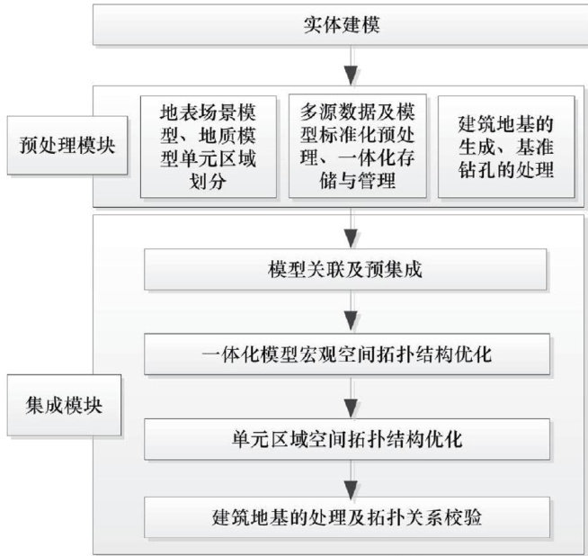
打开文本图片集
中图分类号:P628 文献标志码:A 文章编号:2095-1329(2025)02-0087-08
Research on the construction of an integrated model of above ground and underground based on multi source data: a case study of the southwest third ring road area in Beijing
LI Min
(BeijingInstituteofGeology,Beijing10o195,China)
Abstract:Inrecent years,theconstruction technologyofurban 3Dmodels hasbeenapplied to the planning and research of numerous“digital cities”andkeyurbanareas,greatlyimproving thevisualizationanddatafieldcalculationcapabilitiesof resource surveyandmonitoringresults.Basedontheintegration technologyof multi-sourcedata,this articleproposesageneral framework fortheconstructionofanintegrated3Dmodelofabovegroundandundergroundareas.Keytechnologiessuchasdata storage,networktransmision,andspatialtopologyoptimizationarestudied,andanintegrated3Dmodelofabovegroudand undergroundareas inthesouthwesthirdringroadareaofBeijingisconstructedunifyandtransformmulti-source3Ddatathrough data standardization processng,anduseAI technologyand wavelet transform algorithms forintegratedstorage,management, andtransmisionThesurfacescene modeland3Dgeological modelarecombinedand preprocessedusing thebenchmark driling vectoras theverticalrulerofthestratumoptiizeandadjustthespatialtopologyerorsthatexistintheoverallandunitregions duringthe modelintegrationproces,solvetheconectionproblembetweespatialmodels,andimproveteaccuracyofteated integration.
Key words: model integration; multi-source data; integration ofabovegroundandunderground; 3Dmodel; spatial topology
智慧城市的发展和建设对地理空间数据资源的利用和开发提出了更高的要求,城市建设和发展不仅涵盖地上建筑设施,还需要建立集城市地理空间及地学空间于一体的多维场景城市三维模型。(剩余11922字)
