基于低空热红外影像的城市轨道交通风险安全监护关键技术

打开文本图片集
中图分类号:P631.7;U293.6 文献标志码:A 文章编号:2095-1329(2025)02-0065-07
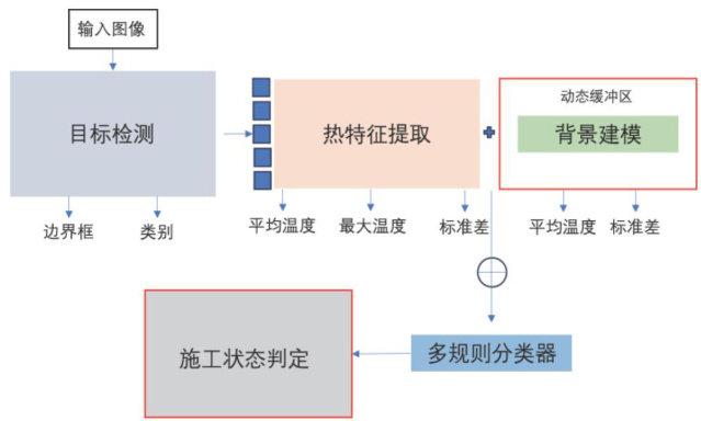
Abstract:Ispeoofailtansitsetyprotectioonsisiticalmeasuefoesuringurbanailtasitsaety.Howeveincoplex noctumalenvironents,traditioalmanalinspectiosandUAVvisiblelightechnoloiesstruggletoetispctionqts.o adresthesecallnges,tispaperproposesaintellgentmoitoringmetodintegratigteralinfraredimageryechnologywiththe YOLOv5 deep learing algorithm.The approach involves equippng unmanned aerial vehicles (UAVs)with thermal infrared cameras for nocturnalimageacquisitioninprotectionzones.TheYOLOv5 modelisemployedfortarget detectionofconstructionequipment intheralinfraredimagery,wilethermalanomalyfeatureextractio,dynamicbackground modeling,andamulti-ruleclasifier arecomprehensivelyappliedtoachieveautomaticidentificationand judgmentofconstruction equipment tatus.This studyselects theLiuchenRoadDepotofShanghaiMetroLine21astheexperimentalarea,conducting testresearchthroughroutedesign,dataset preparation,oeltngdpfoaceaatExpetalsultsemostratecuracipententti statusmonitoring,with theoverall model algorithmprecision reaching 94.33% andaKappacoefficientofO.89.Thismethod effectively fulfillsthedemandsofoctualailtransitispectios,enablingprciserecogitionofnightieconstructionequipmentsafety protectionzones,earlywamingofabnoralenvironmentaltemperaturechanges,anddiscriminationofequpmentoperatingstates.It provides a feasible technical solution for implementing nocturnal inspections of urban rail transit systems.
Keywords:rail tansitsfetyprotectionzoneralinfraredimageryUAV(unmanederialeicle)deepleaingiteliet monitoring
截至2024年底,上海轨道交通已形成896公里运营里程、日均客运量突破1027万人次的超大规模系统[,线路两侧50米(地下段)范围为轨道交通安全保护区,保护区内的违规施工、卸载、加载均会造成隧道变形、漏水甚至破损[2。(剩余9101字)
