国土空间规划实施监测网络功能设计与总体框架
——以山东省为例

打开文本图片集
中图分类号:TU98;F205文献标志码:A
Function Design and Overall Framework of China Spatial Planning Observation Network:A Case Study of Shandong Province
TAN Xuquan ,PEI Shuzhen , AN Guoqiang , JIANG Haiming , LI Yuexia , LIU Zheng SUN Zhiyuan , YU Fengyu , LIU Xinge , LI Bowen , LIANG Tianyu , YANG Jihong
(1.Territory Spatial Planning Institute of Shandong,Jinan 25OO14,Shandong,China; 2.ShandngScientificResearchBasforKeyLaboratoryofLand Use,Ministryof NaturalResources,Jinan 25o4,Shandong,China; 3.Guodi Geospatial Information Technology(Beijing)Co.,Ltd.,Beijing 10oo71,China; 4. China Land Surveying and Planning Institute,Beijing 1Ooo35, China)
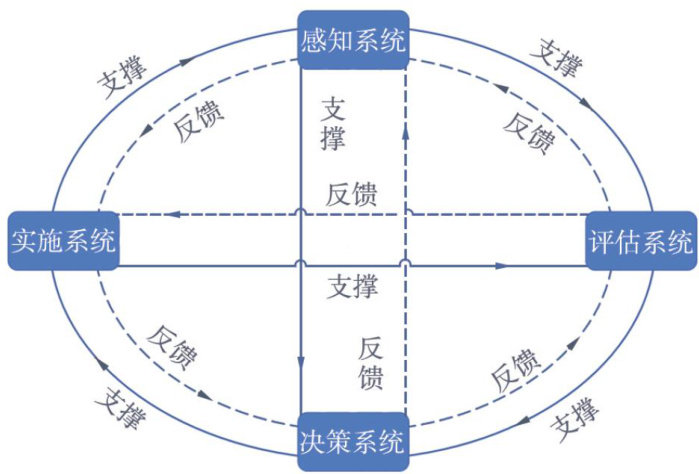
Abstract:To eficientlycarryoutthe implementation monitoring business of territorial spatial planning,methods such as comprehensive analysis and literature colection were adopted tosystematicallysortout thebusiness cycle of teritorial spatial plannng,and the main functions and overallframework of China Spatial Planning Observation Network(CSPON) were proposed.The results show that the appication scenario-driven CSPON must adapt to the nedsof“perceptionevaluation-decision-making-implementation”intheimplementation monitoringof territorialspatial planning,andcorrespondingly build four functional systems,which are perception system,evaluation system,decision-making system,and implementationsystem.Toensue thescientificandorderlydevelopmentof themonitoring network,abasic networkcollborating data networks,decision-making networks,application networks,ecological networks,and support networks shouldbe constructed to integratebigdata acrossindustries and promote the formationof a plannngand decision-making business ecosystem.Based on the practice in Shandong Province,CSPON should make fulluse of existing data foundations and perception technologies,start from planning businessneeds and application scenarios,fully mobilize multiple forces such as governments,scientificresearch institutions and enterprises,and combineemerging technologies suchasartificial intelligence and cloud computing toquicklyand accuratelycaryout intellgent scenario simulationfor planning implementation,evaluation,and early warning,so as to assist in scientific decision-making for teritorial spatial planning.
Keywords: China Spatial Planning Observation Network (CSPON);terrtorial spatial governance;data fusion
随着各级国土空间规划成果的报批,我国国土空间规划体系建设逐步转入实施监测和评估完善阶段。(剩余9932字)
