InSAR约束下的2024年乌什Mw7.0地震同震形变场及断层滑动分布

打开文本图片集
关键词:乌什地震;InSAR同震形变;滑动分布;库仑应力加载
中图分类号:P315.7; P542+ .3 文献标志码:A 文章编号:1000-0844(2025)06—1469—10
DOI:10.20000/j.1000-0844.20241220001
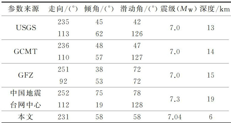
Abstract: On January 23,2024,an Mw7.0 earthquake struck Wushi County,Xinjiang. To investigate its seismogenic mechanism and tectonic characteristics,differential interferometric synthetic aperture radar technology was used to process Sentinel-1A ascending and descending track images,yielding the coseismic deformation field. The results are as follows. (1) The Mw7.0 earthquake induced significant surface deformation over an area of ~90km×70km ,dominated by overall uplift. The maximum deformation in the line-of-sight direction was ~0.8m for the T56 ascending track, ~0.38m for the T34 descending track deformation field,and ~0.55m for the T136 descending track deformation field. (2) Within two months after the earthquake,deformation in the epicentral and surrounding areas tended to stabilize. (3) Fault parameters were determined on the basis of the elastic half-space dislocation model(Okada) and distributed slip inversion.The results indicated that the rupture mechanism of this earthquake was predominantly thrust-dominated,with a moment magnitude (MW ) of 7.04,a strike of ~231∘ ,a dip angle of ~58∘ ,and a rake angle of ~58∘ (4)Using the coseismic deformation as a constraint,combined with the calculation of static Coulomb stress changes on surrounding faults,it is suggested that both ends and the perpendicular directions of the Maidan fault exhibit a relatively high future rupture risk.
Keywords: Wushi earthquake; InSAR coseismic deformation; slip distribution; Coulomb stress loading
0 引言
根据中国地震台网中心测定,北京时间2024年1月23日2时9分,新疆阿克苏地区乌什县 (41.26∘ N,78.63∘E) 发生 Mw7.0 地震,震源深度 22km 。(剩余14111字)
