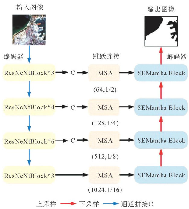
基于Mamba的双分支遥感图像海陆分割模型

打开文本图片集
中图分类号:TP338.6 文献标志码:A
Abstract: Aiming at the problems low accuracy efficiency deep learning models for segmenting complex coastlines in remote sensing images,an efficient sea-l segmentation model(MRU-Net) for complex types coastlines was proposed. The ResNeXt-50 network MRU-Net as an encoder was employed to extract the rich feature information the image, a multi-scale segmentation attention(MSA) module was designed to enhance the weak features at the sea-l boundary. The SEMamba architecture was introduced as the decoder to capture long-range dependencies integrate high low-level semantic information. Model comparison experiments were conducted based on Benchmark Sea-L Dataset(BSD), the results visualization experiments showed that the MRU-Net model achieved 97.75% Mean Intersection over Union on BSD,which can achieve more accurate sea-l segmentation results.
Keywords: remote sensing image; sea-l segmentation;multi-scale segmentation attention
遥感图像中包含复杂的场景和纹理分布,空间信息丰富,海岸线两侧的地物具有独特的特征,陆地土壤和近海沉积物的光谱特征也较为相似,传统的海陆分割方法的准确度较低。(剩余11271字)
