1990一2020年黄河下游大汶河区水系连通性时空变化特征

打开文本图片集
中图分类号:TV213 文献标志码:A
Abstract:To study the spatiotemporal variation of water system connectivity and its driving mechanism under the influence of natural factors and human activities,taking the Dawen River Regionofthe Lower Yellow River as theresearch area, based onthe circuit theoryand the minimum cumulative resistance(MCR)model,the simulated current was used to quantify the water system connectivity in diferent periods in 1990-2020.By using remote sensing image data,combined withthe improved waterbody index,thefloodedareas indiferentperiods wereextracted,andthechangesof watersystem connectivityintheresearcharea wereanalyzed.Theresultsshow that the landuse types inthe DawenRiver Region change significantly.In 1990-2020,theurban landarea was increased by91.64%,thecultivated land area was decreased by 12.04% ,the regional current intensity was changed from O. 68 to O.41,and the water system connectivity was continuously reduced.The distribution pattern is high in the east and low in the west.In 2010-2020 ,the rate of connectivitydecline was sloweddown slightly,which issignificantlycorelated with thedevelopmentof urbanizationand groundelevation.Thereare1 pinchpoints intheidentificationarea,whicharethekeyareas affecting theconnectivityof water system,mostlydistributed inTaishanDistrictand Xintai CityofTai’an City,LaiwuDistrictandGangcheng District of Jinan City. The flooded area in the basin shows an increasing trend,reaching 965.83km2 in 2010,an increase of 15.23% compared with 1990,and an increase of 1.08km2 by 2020. It is mostly concentrated in areas with low connectivity,and the connectivity of the river system shows a synchronous change trend.
Keywords: water system connectivity;spatiotemporal variation;circuit theory;;minimum cumulativeresistance;modified normalized differencewater index;the Dawen River Region
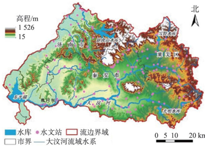
河湖水系是联系海陆水循环的重要纽带,其连通格局对流域地下水补给、洪水滞留、水资源调配及生态环境等方面具有重要功能和价值。(剩余11458字)
