基于多源数据的城市型风景名胜区边界划定研究
——以南京钟山风景名胜区为例

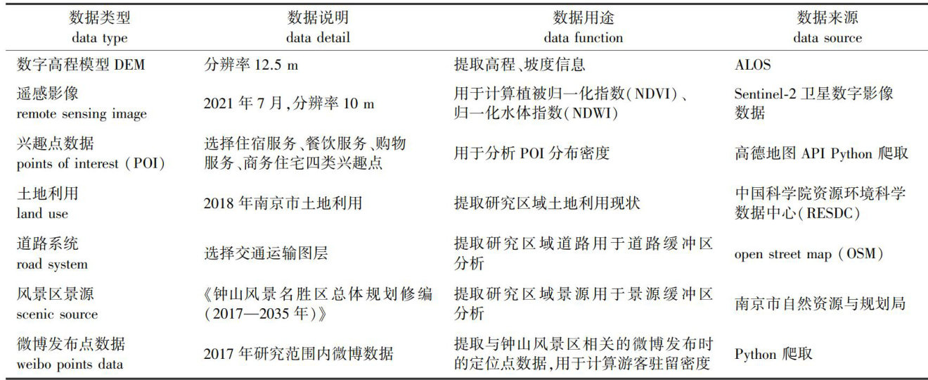
打开文本图片集
中图分类号:TU986 文献标志码:A 文章编号:1000-2006(2025)04-0225-08
Abstract:【Objective】Thisstudyaimsto exploreefectivemethods for identifying boundariesofurbanscenicspotsand to provide a scientific basis for their delimitation.【Method】This study used Zhongshan Scenic Spot as a case study. utilizingmulti-sourcedata,acomprehensive evaluation model forscenicresource grades was constructed.Spatial kernel densityanalysis,fractionalvegetationcover(FVC),GIS reclassification,andoverlayanalysis were employedtocreate scenicresourcesevaluationdistributionmapcategorizedintofivegradesbythenaturaldiscontinuityclasification method:rich,relativelyrich,general,relativelysarce,andscarceinscenicresources.Theaggegatepolygonsfunction in ArcGIS was then used to merge small patches (less than 1 000m2 )into adjacent larger patches and smooth the boundary.Finaly,the boundary of Zhongshan Scenic Spot was delineated based on source protection,tourist density, andrelatedplaning standards.【Result】Theresulting boundarydelineation showed thatthe total area of Zhongshan Scenic Spot was 37.48km2 ,with a new area of approximately 2.06km2 and a reduced area of about 0.49km2 ,resulting inan overall increase of about 1.57km2 compared with the original boundary.【Conclusion】 Supported by multi-source data,this method providesacomprehensiveevaluationmodelthatconsiders landscape,ecology,social environment, andurban development,offering high accuracyandobjectivityfor the protectionandsustainableuseof scenic resources. Kevwords.multi-soure data·houndarvdelimitatinnurhansrenicsnot,kernel densitvanalvsis·resourreevaluation.Zhongshan Scenic Spot
2019年6月,中共中央办公厅、国务院办公厅正式印发了《关于建立以国家公园为主体的自然保护地体系的指导意见》,以国家公园为主体的自然保护地体系正式确立。(剩余16008字)
