遥感技术在典型海湾海域使用动态识别中的研究

打开文本图片集
中图分类号:P717 文献标志码:A 文章编号:1004—6755(2025)07-0031—03
Research on the application of remote sensing technology in spatiotemporal dynamics monitoring of typical bay areas
LIU Ke
(Shenzhen Ocean Development Promotion Center,Shenzhen 5l8ooo,China)
Abstract:To enhance the accuracy and eficiency of spatiotemporal dynamics monitoring in typical bay areas,this study evaluates the applicability of multi一source remote sensing imagery in discriminating typical marine functional zones,such as port operation zones,intertidal buffer areas,and marine aquaculture zones,and using Jiaozhou Bay as the study area, this research integrates multi-source remote sensing data (Sentinel -1 ,Sentinel-2,and MODIS),employs a CNN-RF hybrid algorithm,achieving an overall classification accuracy of 91.68% and a Kappa coeficient of O.869. These results significantly surpass those of traditional SVM methods (81.35% ,0.756) and multi-scale segmentation approaches ( 85.92% ,0.802),thereby validating the superior performance of multi一 source remote sensing fusion and inteligent algorithms in interpreting complex marine environments.
Key words:remote sensing recognition;gulf sea area;dynamic monitoring
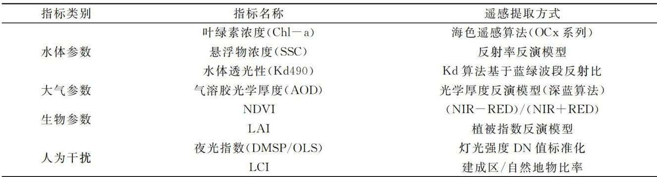
典型海湾海域作为陆海交汇的重要生态空间,承载着密集的人类活动与复杂的自然过程,其空间利用格局与生态环境动态变化密切相关。(剩余3444字)
