动态扫描激光视觉三维测量系统及标定方法

打开文本图片集
关键词:激光雷达;深度相机;垂直运动;联合标定;三维重构中图分类号:TP391.41 文献标识码:Adoi:10.37188/OPE.20253316.2491 CSTR:32169.14.OPE.20253316.2491
Dynamic scanning laser vision three-dimensional measurement system and calibration method
YANG Hongtao*,HUANG Changjiu,PANG Haonan,FAN Ruilin,LIANG Guanglei (College ofMechanical and Electrical Engineering, Anhui University of Science and Technology , Huainan 232001,China) *Correspondingauthor, E -mail:lloid@163.com
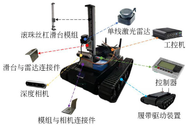
Abstract: Single-layer LIDAR ofers advantages such as simple structure,low cost,and low power consumption;however,its sensing capability is limited to planar scanning,rendering it incapable of independently achieving three-dimensional 3D reconstruction.Although visual sensors provide rich image information,they sufer from limitations in geometric measurement accuracy and robustnessagainst environmental interference. To address the inability of single-layer LIDAR to directly acquire 3D spatial information and the low reconstruction accuracy of single-sensor systems,this paper presented a LIDAR - camera fusionbased 3D reconstruction system. The system employed a lead screw and roller mechanism to drive the single-line LIDAR in vertical motion, enabling spatial 3D data acquisition. Simultaneously,the RGB-D camera captured color and texture information to enhance reconstruction quality. The system architecture and scanning measurement principles were first established,folowed by a detailed analysis of the 3D reconstruction pipeline. Intrinsic and extrinsic calibration between the LIDAR and the camera was performed to enable accurate point cloud registration and fusion,significantly improving the precision and completeness of the reconstruction. A simulated tunnel-like environment was constructed for validation. Using the calibrated system,point cloud coordinates were computed frame-by-frame for the reconstruction of ll target objects. Experimental results show a registration error of 6.8mm ,with fused point cloud deviations not exceeding 5.5mm within a 500mm measurement range. Furthermore,a large-scale indoor floor reconstruction experiment demonstrates an overall reconstruction error within 12mm over a 2 600 mm measurement range.
Key words:LIDAR;depth camera;vertical motion;joint calibration;3D reconstruction
1引言
随着工业检测、机器人导航和数字化建模等领域对高精度三维测量需求的不断提升,光学三维测量方法因其非接触、高分辨率和高效率等优势,已成为研究热点。(剩余13414字)
