基于面向对象与深度学习方法的遥感影像自动提取技术研究

打开文本图片集
摘要:文章在对面向对象多尺度分割技术和深度学习技术分别进行理论、方法阐述后,开展目标区建设用地和非建设用地自动提取实例研究。通过建立少量地类样本库完成遥感影像自动分类提取,并对提取结果进行分析,得出目标区总体分类精度达到94.40%,建设用地的制图精度和用户精度能够满足实际生产需求。
关键词:遥感影像;自动提取;面向对象;深度学习
doi:10.3969/J.ISSN.1672-7274.2023.07.009
中图分类号:P 237,TP 3 文献标志码:A 文章编码:1672-7274(2023)07-00-03
Research on Remote Sensing Image Automatic Extraction Technology Based on Object Oriented and Deep Learning Methods
DOU Yajuan
(Zhongse Blueprint Technology Co., Ltd., Beijing 101312, China)
Abstract: This article conducts a case study on automatic extraction of construction and non construction land in the target area. By establishing a small number of land class sample libraries to complete automatic classification and extraction of remote sensing images, and analyzing the extraction results, it was found that the overall classification accuracy of the target area reached 94.40%, and the mapping accuracy and user accuracy of construction land can meet actual production needs.
Key words: remote sensing images; automatic extraction; object-oriented; deep learning
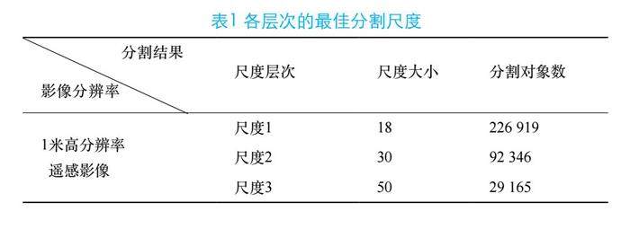
目前,遥感图像解译存在两大难点:一是不同地物难以分割开,二是地物分类不准确。(剩余4348字)
