无人机摄影测量技术在地形图测绘中的应用

打开文本图片集
摘要:随着信息技术的发展,综合考虑工程建设的时效性,无人机摄影测量技术在地形图测绘中的优势越来越突出。文章通过分析无人机摄影测量技术的特点和优势,提出无人机摄影测量技术在地形测绘中的应用方法。
关键词:无人机;摄影测量技术;地形图测绘
doi:10.3969/J.ISSN.1672-7274.2022.09.039
中图分类号:P 217 文献标示码:A 文章编码:1672-7274(2022)09-0-03
Application of UAV Photogrammetry Technology in Topographic Mapping
ZHAO Wenjiao
(School of transportation engineering, Shanxi Vocational University of engineering and technology, Jinzhong 030619, China)
Abstract: With the development of information technology, considering the timeliness of engineering construction, UAV photogrammetry technology has become more and more prominent in topographic mapping. By analyzing the characteristics and advantages of UAV photogrammetry technology, this paper puts forward the application method of UAV photogrammetry technology in topographic mapping.
Key words: UAV; photogrammetry technology; topographic mapping
1 无人机摄影测技术原理及特点
1.1 基本原理
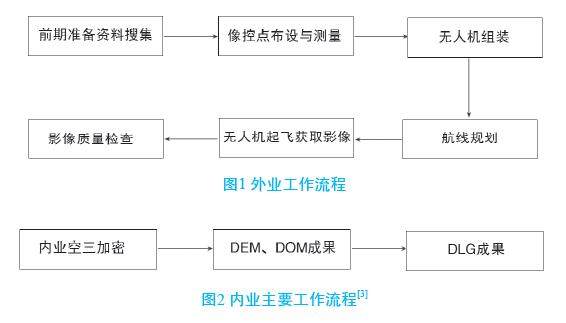
无人机摄影测量技术主要是结合无人机技术和航空摄影测量技术,外业在地面布设像控点,用GNSS-RTK获取像控点坐标,无人机组装后,同时将单镜头、双镜头或五镜头相机安装在无人机下部,通过自带软件进行航线规划,遥控起飞无人机后通过相机获取地面影像。(剩余3957字)
