无人机遥感技术在关闭矿井地质普查中的应用

打开文本图片集
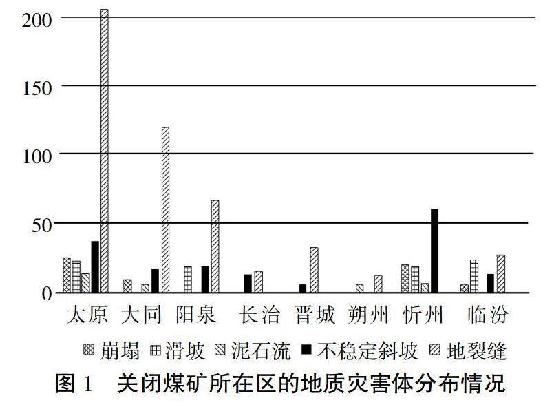
摘 要:该文针对我国关闭矿井逐年增多的现状,以及矿山生态修复的迫切需要,以山西省关闭煤矿地质普查为例,介绍无人机遥感技术的实施方法,阐述遥感图像数据处理流程,分析不同地质灾害体的图像解译和验证方法。该方法精度高、速度快和成本低,建议在关闭矿井地质普查中进一步推广。
关键词:关闭矿井;地质普查;无人机遥感技术;地质灾害体;数据处理
中图分类号:P237 文献标志码:A 文章编号:2095-2945(2023)10-0151-05
Abstract: In view of the increasing number of closed mines in China and the urgent need for mine ecological restoration, taking the geological survey of closed coal mines in Shanxi Province as an example, this paper introduces the implementation method of UAV remote sensing technology and expounds the remote sensing image data processing flow. The image interpretation and verification methods of different geological disaster bodies are analyzed. This method has The advantages of high precision, high speed and low cost, so it is suggested to be further popularized in the geological survey of closed mines.
Keywords: mine closure; geological survey; UAV remote sensing technology; geological disaster body; data processing
关闭矿井是指在当时社会政策和技术条件下停止开采的矿井[1],包括煤矿、金属矿和非金属矿等。(剩余5866字)
