吉林省地壳厚度与 uP/νS 比值及其构造暗示

打开文本图片集
关键词吉林省;松原地区;松辽盆地;长白山区;地壳厚度与 uP/νS 比值中图分类号: P315.3+1 文献标识码:A 文章编号:2096-7780(2025)08-0456-07doi: 10.19987/j.dzkxjz.2024-088
Crustal thickness and uP/νS ratio and their tectonic implication in Jilin Province
Chen Chuang1),Wei Zigen², Fan Xintian2, Cheng Zhiwei³),Deng Qi*4 ,Sun Miao4)
1) Jilin Seismic Station of Jilin Earthquake Agency, Jilin Changchun l3o117, China
2) State Key Laboratory of Precision Geodesy, Innovation Academy for Precision Measurement Science and Technology,
Chinese Academy of Sciences,Hubei Wuhan , China
3)HebeiUniversity ofEngineering,HebeiHandan O56o38,China
4) Department of Geophysics, Yunnan University, Yunnan Kunming 65oo91, China
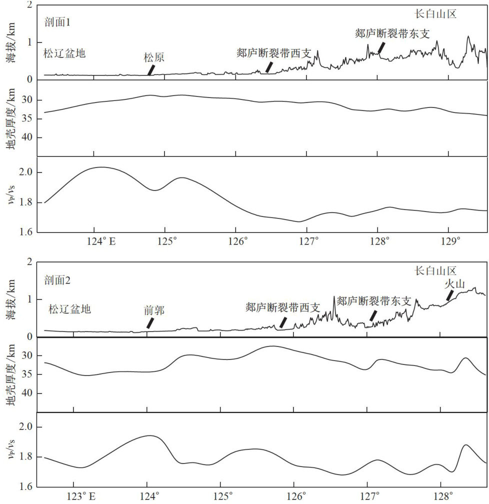
Abstract Using data on crustal thickness and the uP/νS ratio calculated from teleseismic waveforms recorded at five temporarystationsandcollcted from previousstudiesin JilinProvince,weanalyzed thecrustal structure indifferent geological units. The results show that the average crustal thickness in Jilin Province is 32.57km with thinner crust in the middle; the average uP/νS is 1.768 with higher values in the eastern region; crustal thickness in Changbai Mountain area is higher than that in the Songliao Basin,whereas the uP/νS ratio is lower than that in the Songliao Basin. The crustal thickness in the Changbai Mountain area is thin in the west, the uP/νS ratio shows small variation, and the thin crust with the high uP/νS ratio appear in the volcanic eruption area.In the Songliao Basin area, the crust is thin in the east with a high uP/νS ratio, whereas the Songyuan and Qianguo areas with dense earthquakes exhibit substantial lateral changes in crustal thickness and high uP/νS ratios.The thinnest crust and the highest uP/νS ratio is found in the Songyuan area in Jilin Province.
KeywordsJilin Province; Songyuan area; Songliao Basin; Changbai Mountain area; crustal thickness and uP/νS ratio
0 引言
吉林省地处我国东北地区中部,经纬跨度为(40∘52′N~46∘18′N 1 121∘38′E~131∘19′E) ,位于阴山一天山纬向构造的东端与新华夏构造体系的复合部位,处于太平洋板块向欧亚板块俯冲构造背景环境中。(剩余9963字)
