深度学习驱动矿山地表沉陷区多源遥感数据融合

打开文本图片集
中图分类号:TD325;TP391.4 文献标识码:A
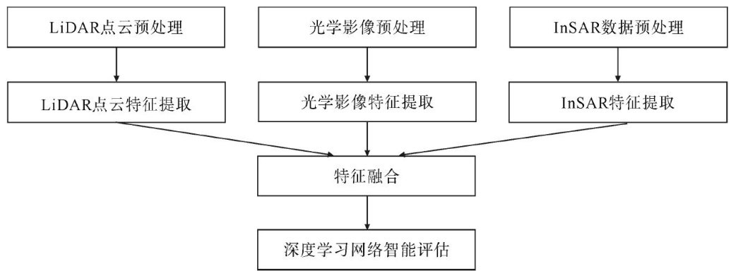
Abstract: Aiming at the problems of insufficient accuracy of traditional methods and limitations of single data sources in mine subsidence monitoring,this study proposes an assessment method for multi-source remote sensing data fusion based on deep learning. By fusing InSAR,optical imagery,and LiDAR point cloud data,a model framework of “data preprocessing-feature extractionfeature fusion-intelligent assessment”is constructed,and U-Net is combined with Transformer (UT-Net) to achieve automatic identification of subsidence areas and inversion of subsidence amounts. Using data from typical mining areas in Shandong Province from 2O2O to 2023 as samples,5-fold cross-validation and multiple comparative experiments show that: the proposed model achieves an Fl score of O.91 in complex terrain areas,which is about 15.2% higher than the model combining single InSAR data with U-Net, significantly enhancing the recognition ability of small subsidence areas; the accuracy fluctuates only 3.2% after adding noise,indicating good robustness;; through the lightweight design of the model, the processing efficiency of a single image is increased by 17.03% . The research results provide a scientific basis and technical support for mine subsidence disaster warning,ecological restoration, and’ intelligent mine construction. Meanwhile,future research directions are proposed, such as combining high revisit rate satellite and UAV data and optimizing the network structure,to further improve the real-time monitoring ability.
Keywords: deep learning; mine subsidence area; multi-source remote sensing data fusion; UT-Net model; intelligent assessment
开采沉陷作为矿山开采影响环境的核心因素,严重制约着绿色矿山的建设进程。(剩余11457字)