大地电磁法在银川盆地北部电性结构探测中的应用

打开文本图片集
中图分类号:P631 文献标识码:A
Abstract: In order to study the deep extension characteristics of the western Helan Mountain eastern foothills fault and the eastern Yelow River fault that control the northern boundary of the Yinchuan Basin,as well as the hidden Luhuatai fault and Yinchuan fault within the basin,Considering previous research methods and scales,the magnetotellurics method was employed to conduct a detailed exploration of the electrical structure in the northern part of the basin.The article obtained the electrical structure information of the middle and deep parts of the northern Yinchuan Basin through long-period magnetotelluric profile measurements for using near-reference processing techniques and impedance tensor decomposition techniques;The 2D NLCG inversion results show obvious electrical zoning characteristics in the northern part of the Yinchuan Basin.The main fault reflects clearly,and a high conductivity channel has been found in the deep part,which is highly likely to be the upwelling of mantle derived material from the deep part. This study indicates that the magnetotelluric sounding method is an important geophysical sounding method for detecting hidden faults,seismic environments in earthquake prone areas, and geological structures related to geothermal genesis in northern part of the Yinchuan Basin.
Key words: Yinchuan Basin;Magnetoteluric;electrical structure;high conductivity channel
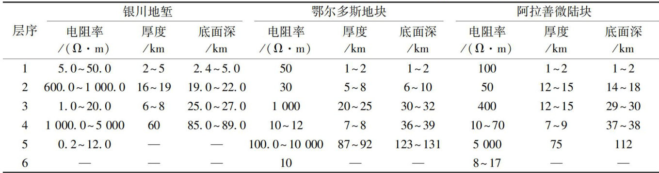
银川盆地是鄂尔多斯周缘新生代断陷盆地的一部分,夹持于阿拉善地块与鄂尔多斯地块之间,且向南与祁连山褶皱带相接。(剩余9866字)
