秦岭造山带及邻区双差层析成像

打开文本图片集
关键词双差层析成像;秦岭造山带;汉中盆地;地壳速度结构中图分类号:P315.2 文献标识码:A 文章编号:2096-7780(2025)05-0249-10doi:10.19987/j.dzkxjz.2024-163
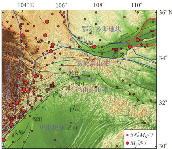
AbstractThe Qinling orogenic belt and its adjacent areas serve as the convergence zone between the North China craton,the Yangtze craton,andthe northeastern edge ofthe Qinghai-Xizang Plateau are characterized bycomplex tectonic activity.This studyutilizes observational data from 159 fixed stations ofthe ChinaEarthquake Administration in Shaanxi, Sichuan,Gansu,andotherregions,as wellas182broadband mobile stations from the ChinArrayI project.Weobtained athre-dimensional velocitystructureof the Qinling orogenicbeltand itsadjacent areas byemploying the doubledifferencetomography method.Theimaging resultsreveal that the crustal thicknessof the Hanzhong basin is approximately 38km ,and the Moho interface exhibits a dome-like shape, convex in the center and concave on both sides. Additionally,a significant low-velocity anomaly is observed along the northern edgeof the western Qinling orogenic belt and the southern side of the Longxian-Baoji fault zone, extending to a depth of approximately 39km This anomaly is associated with the eastward flow of materials from the middle and lower crust of the Qinghai-Xizang Plateau.
Keywordsdouble-difference tomography; Qinling orogenic belt; Hanzhong basin; crustal velocity structure
0 引言
秦岭造山带位于青藏高原、华北块体、扬子块体交汇地带,同时与大巴山造山带、摩天岭地块相交汇。(剩余14452字)
