重庆渝中半岛地上地下一体化三维模型构建与应用

打开文本图片集
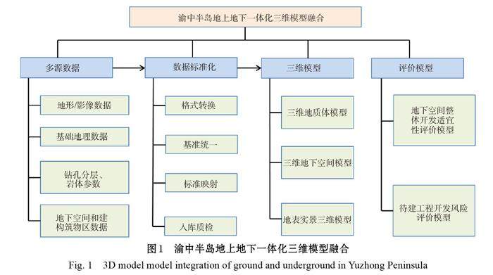
摘 要:为解决城市规划建设中突出的地质问题,重庆市开展了渝中半岛地质调查评价工作,提出了地上地下一体化三维模型建设总体思路,总结了模型在城市地上地下一体化数据管理轨道交通规划选线、地下空间开发利用规划等方面的应用经验,提出了三维模型在服务城市安全监测预警、城市运行管理服务平台建设等方面的建议。
关键词:渝中半岛;三维模型;地上地下一体化;辅助决策
Construction and application of 3D modeling with ground and underground integration in Yuzhong District Peninsula, Chongqing
CHEN Xing1, WEN Jinmei1, ZHENG Zhilin1, WANG Xinya2
(1.Geological Exploration Team 208 of Hydrogeological & Engineering of Chongqing Bureau of Geological and Mineral Exploration (Chongqing exploration and Design Institute of Geological Hazard Prevention and Control Engineering ) , Chongqing 400700, China;
2.Yuzhong District Planning and Natural Resources Bureau, Chongqing 400013, China)
Abstract: In order to solve the prominent geological problems in urban planning and construction, Chongqing has carried out geological survey and evaluation of the Yuzhong Peninsula. A general plan has been made to create an integrated 3D model of above-ground and underground. This paper summarizes the model application experience in urban rail transit line selection, underground space development and utilization planning and so on. Suggestions are also put forward on the application of the 3D model in urban safety monitoring and early warning, and urban operation management service platform construction.
Keywords: Yuzhong Peninsula; 3D modeling; integration of ground and underground; supporting decision-making
随着城市化进程的不断发展,城市系统安全、城市安全运营、未来地下空间合理规划布局等一系列问题也逐渐凸显。(剩余6805字)