星载激光雷达足印点质量对获取森林冠层高度的影响

打开文本图片集
中图分类号:S771.8 文献标志码:A 文章编号:1673-923X(2026)03-0197-11
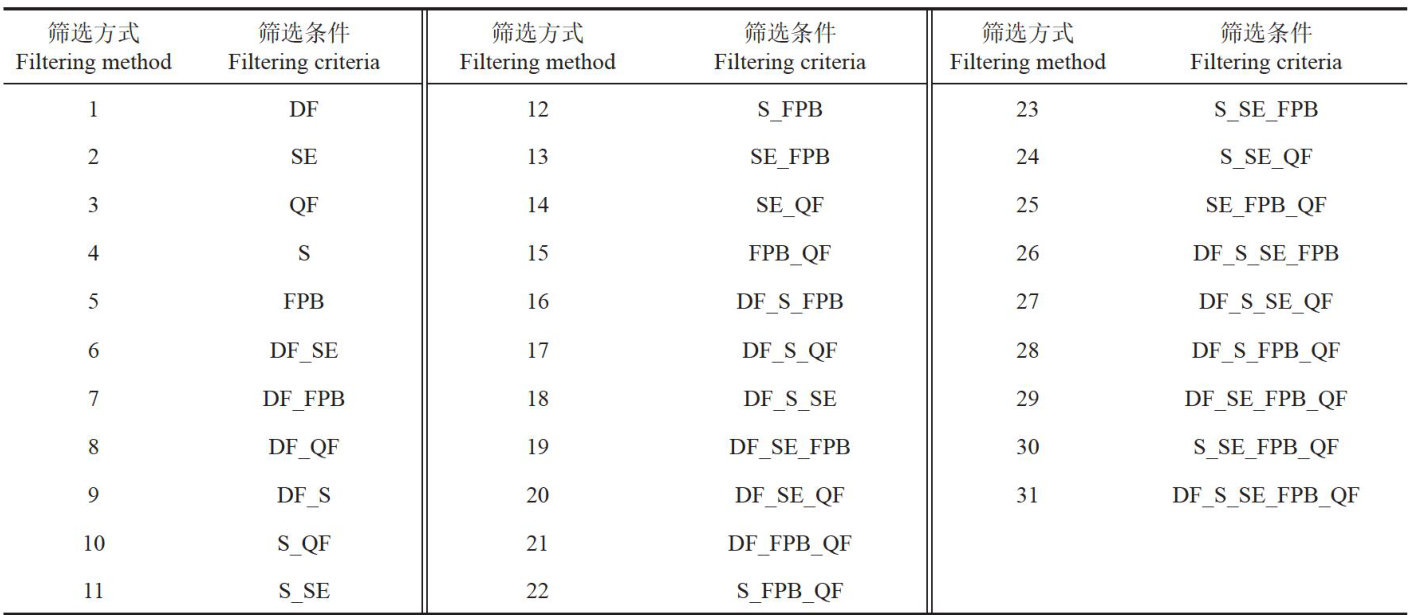
Abstract:【Objective】Tocompare the impactofspaceborneLiDAR footprintqualityunder diferentscreeningconditionsonforest canopyheightextractionprovidingaferenceforteprecisetimatioofforesttructuralparametersusingspaceboeLDAdata. 【Method】Theresearch wasconductedintheHarvardForest,WorcesterCounty,Massachusets,USA.GEDIparameterscluding qualityfagegadefsiiityolaetiondfullareedflngdsodels werebuiltunderdiferentconditions toestablshcanopyheightmodels.Byanalyzingthevariationsinmodelaccuracyunderdieent qualityflteringconditions,theoptimalscreningmethodforspaceboreLiDARfootprintshotswasdetermined.【Result】l)Under single-criterionflringtheegradationfagieldedthebestpformance.Compaedtoteufltereddataquaityflteringproed the accuracy of forest canopy height retrieval,reducing theRMSE by 6.97% ;2)Multi-criteria combination filtering further enhanced theauracytialatioomprsingthaitygegadtionfagsiiityoretiogledr beam-reduced the RMSE by 20.48% compared to the unfiltered data; 3) Some combined conditions (e.g.,solar elevation angle with qualityfg)esdiedcydtitotllioseeay;4)optlo mainly occurred in areas with canopy heights between 18m and 36 m;5) The combination of quality flag,degradation flag,and sensitivity outperformed the optimalcombination inregional interpolation mapping,reducing the RMSE by 4.25% compared to the bestcombination.【Conclusion】Fooprintqualityflteringimprovestheestimationaccuracyofforestcanopyheight,andcombied flteringethodsaremorebeneficialtansingleflterigmethodsinobtaininghgualitydata.However,thescreeningstrategied atsingle-pointaccuracyduringthemodelingphaseisnotoptimalforregional-scalespatialmappingtasks.Byselectingapoprate fltering conditios,moreacurateforesttucturalparameterscanbebaedrovidingrelabletechicalsupportforfestsouce monitoring and management.
Keywords: forest canopy height; footprints; quality filtering;GEDI; random forest model
森林冠层高度是表征森林垂直结构的关键参数,持续、大规模地监测森林高度能够为分析森林退化、量化森林恢复及估算碳排放量等提供关键数据支持[1]。(剩余12663字)